


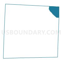
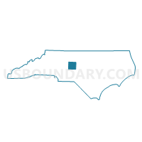
Voting District 23, Randolph County, North Carolina
About
Outline

Summary
| Unique Area Identifier | 641231 |
| Name | Voting District 23 |
| County | Randolph County |
| State | North Carolina |
| Area (square miles) | 22.79 |
| Land Area (square miles) | 22.56 |
| Water Area (square miles) | 0.23 |
| % of Land Area | 99.00 |
| % of Water Area | 1.00 |
| Latitude of the Internal Point | 35.87710370 |
| Longtitude of the Internal Point | -79.58389340 |
Maps

Graphs
Select a template below for downloading or customizing gragh for Voting District 23, Randolph County, North Carolina


Neighbors
Neighoring Voting District (by Name) Neighboring Voting District on the Map
- Voting District 01, Alamance County, NC
- Voting District 3, Chatham County, NC
- Voting District 30, Randolph County, NC
- Voting District 35, Randolph County, NC
- Voting District GR, Guilford County, NC
- Voting District SCLAY, Guilford County, NC
Top 10 Neighboring County Subdivision (by Population) Neighboring County Subdivision on the Map
- Clay township, Guilford County, NC (7,359)
- Columbia township, Randolph County, NC (7,016)
- Liberty township, Randolph County, NC (5,792)
- Township 1, Patterson, Alamance County, NC (4,869)
- Greene township, Guilford County, NC (3,386)
- Albright township, Chatham County, NC (2,584)
Top 10 Neighboring Place (by Population) Neighboring Place on the Map
Top 10 Neighboring Unified School District (by Population) Neighboring Unified School District on the Map
- Guilford County Schools, NC (488,406)
- Alamance-Burlington Schools, NC (151,131)
- Randolph County Schools, NC (113,222)
- Chatham County Schools, NC (63,505)
Top 10 Neighboring State Legislative District Lower Chamber (by Population) Neighboring State Legislative District Lower Chamber on the Map
- State House District 54, NC (83,728)
- State House District 58, NC (83,145)
- State House District 64, NC (80,704)
- State House District 70, NC (72,392)
Top 10 Neighboring State Legislative District Upper Chamber (by Population) Neighboring State Legislative District Upper Chamber on the Map
- State Senate District 18, NC (207,334)
- State Senate District 26, NC (196,857)
- State Senate District 24, NC (174,850)
- State Senate District 29, NC (169,550)
Top 10 Neighboring 111th Congressional District (by Population) Neighboring 111th Congressional District on the Map
Top 10 Neighboring Census Tract (by Population) Neighboring Census Tract on the Map
- Census Tract 202, Chatham County, NC (7,666)
- Census Tract 310, Randolph County, NC (7,151)
- Census Tract 312, Randolph County, NC (5,336)
- Census Tract 170, Guilford County, NC (4,516)
- Census Tract 218.03, Alamance County, NC (2,879)